About the FLOODRESC project

Summary

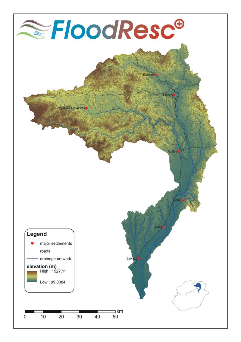
The aim of the project is to support the disaster management authorities of B-A-Z and Kosice county and to improve the efficiency of their activities in case of flooding by the development of a demonstrative GIS tool. The project includes flood modelling to predict the size and location of the flooded area, the analysis of effects of floods on the natural and human environment, the optimization and planning of logistic tasks, and the handling of public health and epidemic effects of floods. The target area is the catchment area of Hernád/Hornád river. Due to the cross-border nature of disasters, the project objectives could be achieved more efficiently by the framework of a Hungarian-Slovakian joint cooperation. The results of the project will ensure prompt data and information to support the decision making of disaster management authorities, and provide a potentially secure environment for the inhabitants and enterprises.

To achieve these aims, an integrated, multi-purpose GIS database will be developed, including all data necessary for flood modelling, the spatial data layers of key objects, buildings, infrastructural elements, available equipment and resources in sufficient detail. The flood modelling tool - on the basis of GIS database - will be capable to predict the extent of flooded area occurred by a potential dam failure. On the basis of the database and outputs of flood modelling, a logistical modelling tool will be developed to optimize and plan the logistics tasks and activities (e.g. transportation, evacuation). An EIA and a disaster-medicine protocol will be elaborated as well to manage better the public health and epidemic effects of floods.

The entire decision support tool will be capable to provide up to date information for the disaster management authorities to make better decisions. The project objectives are in line with 2000/60/EC directive, establishing a framework for community action in the field of water policy (3), (23), Article 1).

Partners

  • University of Miskolc (as lead partner)
  • Technická univerzita v Košiciach (TUKE)
  • Vysoká škola bezpeènostného manažérstva v Košiciach (VSBM)
  • Holocén Nature Conservation Association
  • BAZ County Disaster Management Directorate (BAZMKI)
  • Duration

    01/11/2017 – 31/10/2019

    Budget

    450.160,90 EUR

    Project objectives

    The overall goal of the project is to support the Disaster Management Authorities (DMA) by providing them a toolset for flood modelling, forecasting the size and location of the affected area and the affected population; identifying relevant objects and human infrastructure in risk, or objects needed for handling the crisis, and to develop a GIS based logistics pilot framework to better manage the human and natural resources for the disaster management. In our previous project (Floodlog, HUSK/1001/2.1.2/009 - that had been selected as a best practice cross-border project by the EU) similar, but less developed version of this decision support tool had been elaborated. In this recent project our goal is to cover the Hernád/Hornad catchment area. The overall, long-term objective of the consortium is to strengthen and improve the cooperation efficiency between SK and HU disaster management authorities on the field of risk prevention through joint IT development; and to provide a more secure environment for the inhabitants.

    The direct objectives of the project are the following:

    1. Joint development of a harmonized, integrated GIS database for the Hernád/Hornad catchment
    2. Flood modelling tool development to provide information for flood crisis management
    3. Environmental impact assessment study to take into account all the effects of floods on the natural environment
    4. Development of GIS based logistical modelling tool for crisis management, that can be a start point for compilation of Mission Control Plans, to analyse the outcomes of possible logistic activities, and to support decision making in case of flooding
    5. Elaboration of disaster-medicine protocol to handle the public health and epidemic effects of floods.
    Content Image

    Acitivities

    1. Specification of model details

      Specification of the model details based on the needs and requirements of the Disaster Management Authority and on the feasibility of the planned system. Based on the expected functions, targeted outputs of the models, the input data need for supporting the flood modeling, logistic modeling, disaster-medicine protocol development activities have to be specified as well. The layers needed for the operational work of crisis management are defined by the DMA.
    2. Development of data layers

      Development of the data layers specified in the Act1. This is the largest activity in budget and in time as well. Several experts from the two sides have to be involved for the data harmonization work. Bilateral scientific teams for all thematic data layers will be set up to survey the available national data and develop the harmonization strategy for the common, harmonized database, covering the two sides. This DB can be used for any regional development, environmental modeling tasks as well.
    3. Database and toolset harmonization

      The extension of the project results by the modification and completion of existing cross-border databases for testing the tools and models. The existing cross-border data set covers the whole Bodva catchment area where similar but not identical dataset was developed in a previous Interreg project called Floodlog.
    4. Disaster-medicine protocol development

      On the basis of the project results (joint GIS db, outputs of flood and logistical models) a disaster-medicine protocol will be developed for the Hernád catchment. This protocol will be developed by the Lead beneficiary and external experts. The protocol can be applied for:
      -in situ classification of injuries (triage)
      -managmenet of hazardous materials
      -providing shleters and clothing
      -preventing epidemics, the spread of infectious diseases
      -critical incident stress debriefing
    5. EIA of the floods

      Environmental Impact and Risk Assessment of the floods on soils and subsurface water system. An environmental and flood based landscape classification will be developed in the Hernád catchment, and the potential risk types are going to be tested and summarized as well.
    6. Flood modeling

      The goal of this activity is to develop a flood modelling application. This "model" will be capable to forcast the size and location of the flooded area in case of a dike failure in the Hernád/Hornád catchment area. The output of the model will be a flood map, showing the outspreading of water. On the basis of this map the number, location of the endangered values (inhabitants, infrastructural elements) can be determined.
    7. Logistic DB development and modeling

      A demonstrational GIS based logistic modeling is developed and applied to the Hernád catchment aiming to support the decision making in a flood crisis situation. The developed model can contribute to a more resilient and effective decision making to prevention and remediation activities.
      The model will justify being a potential tool for supporting preparation of strategic and operative plans for flood crisis situations. The logistic modeling must be served by a comprehensive logistic database.

    Expected results

    1. GIS database: a jointly developed, harmonized set of spatial data layers, covering the whole Hernád catchment area, that contains all the necessary information for the flood- and logistical models, and for the development of disaster-medicine protocol. This will be a multi-purpose database, that can be used for any regional development activities. The database will be developed from the fragmented databases available at DMAs on both sides.
    2. Flood model: an application to predict the size and location of the flooded area in case of a dike failure in the Hernád-valley. This model will provide up-to-date information on the extent and depth of the water. The outputs of the model are digital flood maps, indicating the flooded area by polygons. The model will be installed at the DMAs, where the experts of these organizations can run the model.
    3. Logistical model: on the basis of the GIS database and the flood maps, the logistical model will be capable to determine the location and exact number of endangered values (inhabitants, infrastructure, roads), to plan the required capacities (e.g. shelters), and to create routes for the vehicles. The model will be developed in ESRI ArcGIS environment (the GIS software used by the authorities), and will be installed at the DMAs.
    4. Environmental impact assessment study: this document will take into account all those factors (hazardous materials, pollutants, etc. ), that can harm the physical environment, especially the soils and the water resources; and the human population of the target area.
    5. Disaster-medicine protocol: this study will be developed to manage the location- and task specific epidemic effects of floods on the public health.
    Top